Fourteen-day Photographers’ Silk Road Tour

the Echoing Sand Dunes Dunhuang001w.jpg    The silk road attracts photographers to travel along the route with its amazingly gorgeous landscape. It has become a dream destination for the photographers in recent years. Photography is not only a hobby, but also a very hard work. In order to make it easier, China West Trip has combined the top attractions together along the silk road and delivered a special tour package for the photographers. The itinerary below is devoted to those whose main interests are photography and hiking.

Highlights:

The Heavenly Mountain and Heavenly Lake National Park

Kanas Lake

Kaktokay National Park

The Echoing Sand Dune

Zhangye Danxia Landform National Geo-Park

Qinghai Lake and Chaka Salt Lake

USD?p/p base on ? persons/people

Suggested Itinerary:

  • Day1Urumqi Arrival

        As the capital city of Xinjiang Uighur’s Autonomous Region, Urumqi is the most easily accessible city to travelers in Xinjiang. You will meet your guide and driver at Urumqi Diwopu International Airport(URC), and then be escorted to your hotel in downtown Urumqi.

  • Day2Drive to Visit the Heavenly Mountain and Heavenly Lake National Park

        You will spend a whole day to tour in the Heavenly Mountain and the Heavenly Lake Scenic Area. The scenic area lies 97 kilometers(60 miles) to the east of downtown Urumqi. It is a five-star scenic area and a national geo-park. The park was added to the list of world natural heritage sites by UNESCO in 2013. Its wonders are the snow-capped mountains, the picturesque lake, and the folk custom of Uighur. The view of the mountain and the lake is very gorgeous.

  • Day3Fly to Burqin From Urumqi

        In the early morning, you will be transferred to Urumqi International Airport from your hotel and travel to Burqin by plane. There is only one flight to Burqin from Urumqi during the summer. The plane takes off at 8:30 a.m. and lands at 9:50 a.m.. You need to leave your hotel for the departure lounge before 6:30 a.m., so that you can catch the flight. When you arrive at Buqin Kanas Airport(KJI), your will be picked up by your guide and taken to your hotel near the entrance of Kanas Lake National Geo-Park. The distance between the airport and the park is 48 kilometers(30 miles). You will check in at your hotel first, and then be guided to visit Kanas Lake.

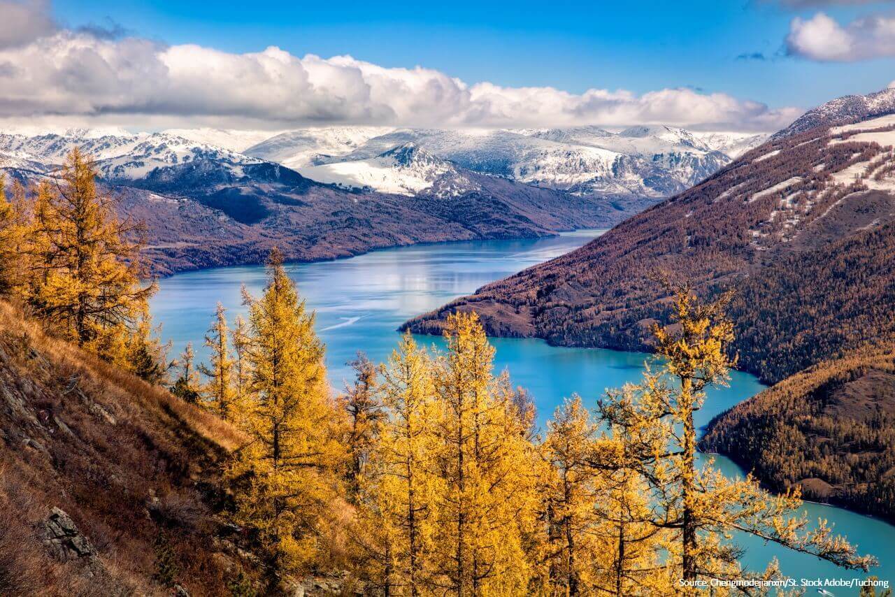
        Kanas Lake lies at the border region between China, Russia, Kazakhstan and Mongolia. It is a national geo-park and a five-star scenic area. The geo-park covers an area of 10,030 square kilometers(3,873 sq.mi). Well-known as the Wonderland on the Earth, Kanas Scenic Area attracts the photographers with its stunning glacial landscape. Set in the U-shaped valleys, Kanas Lake is surrounded by snow-capped mountains, creating a breathtaking scene that seems unreal. Its waters are the most amazing color, a rich shade of turquoise that changes in intensity through summer as the glaciers melt. The lake measures about 45 square kilometers(17 sq.mi) and 188.5 meters(618 feet) in depth. It is the deepest moraine lake in Mainland China. The must-see sightseeing spots in the park are the Crouching-Dragon Bay, the Moon Bay, the Fairy Bay and the Fish-watching Pavilion.
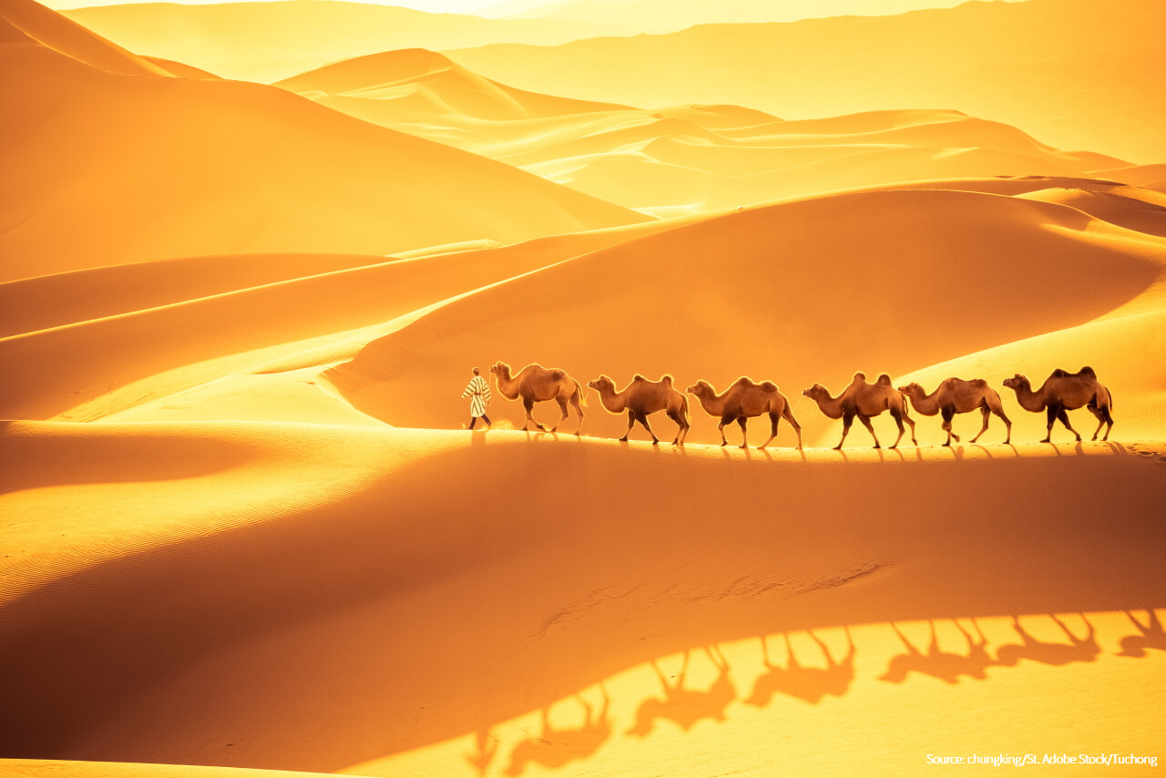
  • Day4Pay a Visit to the Fish-watching Pavilion and the Multi-colored Beach

        In the morning, you will go to visit the Fish-watching Pavilion. The pavilion is situated on a mountain peak overlooking the huge Lake. The mountain is called Halakaite which originated from Mongolian, meaning a camel in English. The attitude of the peak is 2,030 meters(6,660 feet) above sea level. It provides a panoramic view of Kanas Lake.

        After having lunch, you will ride your private car to visit the Multi-colored Beach Scenic Area. The scenic area lies about 120 kilometers(75 miles) to the south of Kanas Lake National Geo-park. It covers an area 300 hectares(741 acres). As a result of erosion, many gullies have been sculpted on the surface of rock strata by both wind and water. The gullies vary in color and in depth. The landscape of the Multi-colored Beach is amazingly gorgeous. The distance between the Multi-colored Beach and the county seat of Burqin is 24 kilometers(15 miles). By the evening, your guide and driver will escort you back to your hotel in Burqin.

  • Day5Travel to Fuyun County and Visit Koktokay National Geo-park

        You will leave Burqin for Fuyun in the morning, be guided to Koktokay National Geo-park and be transferred to your hotel in Fuyun County in the late afternoon. The distance between Burqin and Fuyun is about 260 kilometers(162 miles). It takes about 4 hours to drive between the two towns. Koktokay is rich in mineral and sightseeing resources. The geo-park is 57 kilometers(35 miles) from the county seat of Fuyun. It has a huge spread of 788 square kilometers(304 sq.mi). The Irtysh River flows through the park, creating a dramatic canyon. As a five-star scenic area, the landscape of Koktokay features rolling mountains, murmuring streams, picturesque glacial lakes, virgin forests and verdant pastures. Natural attractions in Koktokay Geo-park include the Irtysh Grand Canyon, the Grove of Birch Trees, the Bell-shaped Hill, etc.

  • Day6Leave Fuyun for Urumqi

        You will set off for Urumqi after breakfast. Fuyun County is located about 470 kilometers(292 miles) to the north of Urumqi. It takes about six hours to get to Urumqi from Fuyun by car. On the way, you will pass through the Callamelli Ungulate Nature Reserve and Huoshao Mountain. In the late afternoon, you may go to visit Xinjiang International Grand Bazaar. It is the largest bazaar in the world, covering an area of 3.98 hectares(9.9 acres).

  • Day7Travel to Dunhuang from Urumqi by Bullet Train

        In the morning, you will ride a bullet train to Dunhuang from Urumqi. The distance between Dunhuang and Urumqi is about 990 kilometers(615 miles). The ride takes only 4 hours. In the afternoon, you will be guided to visit the Echoing Sand Dune and Crescent Lake National Park. The park is also known as Mingsha Mountain and Yueyaquan Lake. It lies in the south suburb of Dunhuang. The view of the sand dunes is amazingly gorgeous. The sand dunes often echo in sunny days. It sounds like the orchestral music. Sometimes, visitors can hear it, when they slide downhill from the top of the sand dunes. The Crescent Lake refers to a stunningly beautiful pool which is in the shape of a crescent moon. It is surrounded by the sand dunes. There is an oasis nearby the pool, small but lovely.

  • Day8Pay a Visit to Mogao Grottoes and Drive to Jiayuguan

        In the morning, you will go to visit the world famous Dunhuang Mogao Grottoes. After having lunch, you will ride your car or coach to Jiayuguan. The distance between Dunhuang and Jiayuguan is about 370 kilometers(235 miles). It takes about four hours to get to Jiayuguan from Dunhuang by car. You will stay overnight in a hotel in downtown Jiayuguan.

        Well-known as the oriental Louvre, Mogao Grottoes are a treasure trove of artworks and antiques. The assemblage of statues and murals has revealed the history of the Silk Road and Chinese Buddhism. It is also known as the Thousand-Buddha Grottoes. The carving project began in 366 and lasted for almost 1,000 years. The site of the grottoes is located 25 kilometers(15.5 miles) to the southeast of downtown Dunhuang. It was added to the list of world cultural heritage site by UNESCO in 1987. The admission charges to the grottoes also include the access to the Digital Exhibition Centre where visitors can watch two movies. The first movie explains the history of the site and the second one is an impressive 3D movie unveiling the mystery of some grottoes at the site which are still off limits to the general public. Both the movies are about 20 minutes in length.

  • Day9Pay a Visit to Jiayuguan Fort and Travel to Zhangye

        You will go to visit Jiayuguan Fort and the Overhanging Wall in the morning, and take your car or coach to Zhangye in the afternoon. The distance between Zhangye and Jiayuguan is about 220 kilometers(137 miles), taking around three hours by car or by coach. You will spend the night in a hotel near the entrance of Zhangye Danxia National Geo-park.

        Jiyuguan Fort is well-known as the No.1 Pass of the Great Wall or the Most Magnificent Fort under Heaven. It can be dated back to the year of 1372. The ancient fort covers an area of 2.5 hectares(6.17 acres). It is a complex, consisting of towers, ramparts and some other military buildings. The fortress town is enclosed by two ramparts, namely the outer rampart and the inner rampart. The outer rampart is 13.4 meters(44 feet) in height and 733 meters(2,405 feet) in circumference. It connects the fort with the Great Wall. The inner rampart is 10.7 meters(35 feet) in height and 640 meters(2,100 feet) in circumference. There are two gates built along the inner rampart. Both are huge gate towers. Visitors can climb up the walkways to the top of the rampart and the Great Wall.

        An optional activity recommended to you is to visit the Overhanging Wall before leaving for Zhangye. The Overhanging Wall is called Xuanbi Wall in Chinese. As a section of the Great Wall, it lies about 8 kilometers(5 miles) away from Jiayuguan Fort. The wall is built on a lofty ridge with an incredibly steep gradient. It looks like an cantilever sticking out the ridge.

  • Day10Tour in the Ice-Valley Danxia Scenic Area and Zhangye Danxia National Geo-park

        You will go photographing in the Ice-Valley Danxia Scenic Area in the morning and take photos in Zhangye Danxia National Geo-park in the afternoon. The former is called Binggou by locals, and the latter is well-known as the Rainbow Mountain. The Ice Valley lies in the west of the national geo-park. It attracts visitors with its oddly shaped hills and cliffs. The Rainbow Mountain is situated 37 kilometers(23 miles) to the west of downtown Zhangye. It is one of the must-go destinations for the photographers. You will not miss the photographic golden hour at the Rainbow Mountain. Danxia is a special landform in China which features its spectacular view of red cliffs and rugged landscape. Developed on continental red terrigenous sedimentary beds, Danxia landform has been influenced by endogenous forces, including the upthrust, and sculpted by exogenous forces, such as the weathering and erosion.

  • Day11Travel to Xining by Bullet Train and Drive to Chaka Salt Lake

        In the morning, you will ride your car or coach to Zhangye West Railway Station and travel to Xining by bullet train. The distance between Zhangye and Xining is about 340 kilometers(211 miles). The train departs at 9:03 a.m. from Zhangye and arrives at Xining at 11:09 a.m.. You need to leave your hotel for the railway station before 7:15. Your guide will take you to a local restaurant in downtown Xining for lunch. After lunch, you will take your car or coach to Chaka Salt Lake. The lake lies about 300 kilometers(186 miles) to the west of Xining. It is one of the top four attractions in Qinghai Province. Chaka Salt Lake is well-known as China’s Mirror of the Sky. The salt lake covers an area of 105 square kilometers(41 sq.mi). The view of the salt lake is breathtaking. It can rival the famous Uyuni Salt Flat in Bolivia.

  • Day12Pay a Visit to Chaka Salt Lake and Drive to Qinghai Lake National Park

        You will be guided to Chaka Salt Lake in the morning, ride your car to Qinghai Lake after having lunch, and visit some sightseeing spots on the east shore of Qinghai Lake. You will spend the night in a hotel nearby the park.

        Qinghai Lake lies in the northeast part of Qinghai-Tibet High Plateau, 145 kilometers(90 miles) to the west of downtown Xining. It is the largest inland saltwater lake in Mainland China. The lake measures about 4,500 square kilometers(1,737 sq.mi). It is also called Tso-Ngonpo by Tibetans. Tso-Ngonpo is a Tibetan word which means a blue lake in English. The view of the lake is stunning. Some of the most ideal sightseeing spots along the shore of the lake are Erlangjian Peninsula, the Ear-Shaped Bay, the Golden-Sand Bay, the Sandy Beach Peninsula, the Fairy Maiden Bay and the Birds’ Isle. A vast field of oilseed rape lies on the north shore of the lake. The rape plants bloom between July and August. Qinghai Lake is not only a wonderful place for the landscape photographers, but also an ideal destination for the birdwatchers. Some islets are surrounded by water. One of the islets is called the Birds’ Isle. It is a paradise for over 100,000 migratory birds, such as bar-headed geese, wild ducks and brown-headed gulls. The best time for bird-watching is between April and June.

  • Day13Tour around Qinghai Lake and Travel back to Xining

        You will go to visit some sightseeing spots on the west and north shores of Qinghai Lake in the morning, and travel back to downtown Xining by car or coach in the afternoon. On the way back to Xining, you will pay a visit to the Sun-Moon Mountain and Kumbum Monastery.

        The Sun-Moon Mountain is situated about 100 kilometers(62 miles) to the west of downtown Xining. It is called Riyue Mountain by the locals. The mountain pass is 3,520 meters(11,549 feet) above sea level. It was an important point of the Ancient Tang-Tibet Path. It is said that Princess Wencheng passed the mountain pass when she traveled to Tibet with her retinues in 641.

        Kumbum Monastery was built in the year of 1379. It is one of the six most famed Ge-lug-pa lamaseries, is the birthplace of Master Tsongkhapa who founded the Ge-lug-pa Sect of Lamaism. The monastery houses many priceless art treasures, such as murals and Tangka paintings. It is also called Ta’er Monastery by the locals. Both Dalai Lamas and Panchen Lamas preached the word of Buddha at the monastery.

  • Day14An Inner-city Tour and Departure from Xining Caojiapu International Airport

        In the morning, you will go to visit Dongguan Grand Mosque of Xining and be transferred to Xining Caojiapu International Airport. The mosque can be dated back to the Ming Dynasty(1368-1644). It is one of the top four mosques in Northwestern China.

Services Included:

√ On-line professional consultancy

√ Hotel accommodation with breakfast

√ Sightseeing shuttle bus in Zhangye Danxia National Geo-park, Mogao Grottoes and the Heavenly Mountain

√ Helpful local guide

√ Well-trained professional driver and comfortable vehicle with ample space

√ Mineral water(one bottle of mineral water per person per day)

√ Entry to all attractions listed on your itinerary, except for the Overhanging Wall in Jiayuguan

√ 24-hours helpline covering the whole of your tour

What's excluded:

Entry to any of the optional activities

Meals not mentioned in the itinerary

Personal expenses

Tipping

Travel Tips:

    1. The sun’s ultraviolet rays are responsible for both tanning and burning. Please pack the suncream, sunglasses and sunhats for your tour along the Silk Road.

    2. The best time to visit Northern Xinjiang is between June and September.

    3. It is necessary to make a reservation minimum 7 days in advance for the visit to Mogao Grottoes in the peak season of Tourism. The peak season lasts from May to October each year.

    4. In the summer, visitors are allowed to stay in the Sand Dune and the Crescent Lake National Park as late as 9:30 P.M., so that they can enjoy the beautiful sight of starry sky. It is quite hot in the afternoon between 1:00 P.M. and 3:00 P.M. at the sand dune. It is highly suggested not to go to visit the park before 3:00 P.M..


Related Articles:


Author: Tina Luo

Update:

Kanas Lake
Kanas Lake
the Crescent Lake
the Crescent Lake
the Heavenly Lake
the Heavenly Lake
Zhangye Rainbow Mountain
the Silk Road
the Silk Road
the Rainbow Beach
the Rainbow Beach