Zhangye Danxia Geo-park

Name in Chinese: 张掖丹霞 Zhāng Yè Dān Xiá [dzæŋ’je-dæʃa:]
Duration of Tour: Half a Day or a Whole Day
Location: Linze County, Zhangye Prefecture, Gansu Province
Highlights: the Dramatic Danxia Landscape, Photography and Hiking
Reputations: One of World’s Must-go Destinations for Photographers, a World Geo-park a National Five-star Scenic Area
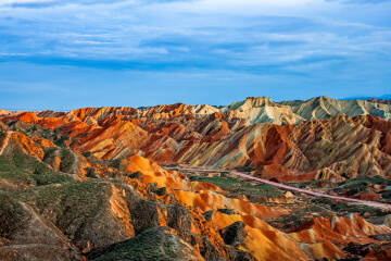
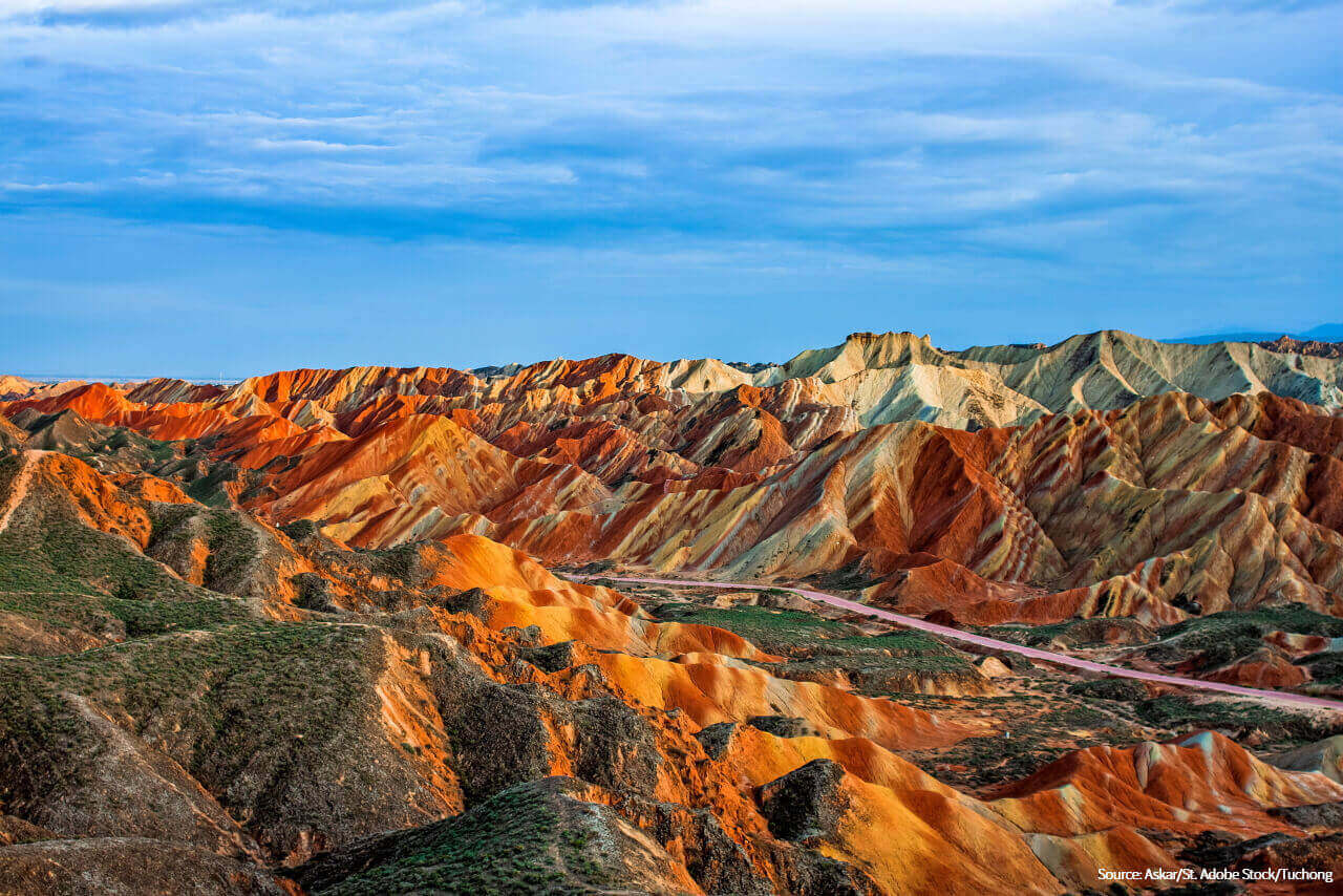
Danxia is a special landform in China which features its spectacular view of red cliffs and rugged landscape. Developed on continental red terrigenous sedimentary beds, Danxia landform has been influenced by endogenous forces, including the upthrust, and sculpted by exogenous forces, such as the weathering and erosion. There are nearly 800 sites of Danxia landscape in China. Zhangye Danxia National Geo-park is the most typical and beautiful one. According to a study, the dramatic landscape of Zhangye was formed over six million years ago. In the year of 2020, it was designated as a world geo-park by UNESCO. The geo-park consists of two scenic areas, namely the Rainbow Mountain and the Ice Valley.
The Rainbow Mountain
The Rainbow Mountain is a national five-star scenic area. It is situated 37 kilometers(23 miles) to the west of downtown Zhangye, covering an area of over 200 square kilometers(77 sq.mi). The scenic area is noted for its rocks with a wide range of colors. Its average altitude is 1,850 meters(6,070 feet) above sea level. Due to natural weathering and erosion, colourful hills and mounds are sculpted into various shapes, such as, mushrooms, pagodas and scallop shells. There are eleven sightseeing spots in the scenic area. They each are named according to their individual shapes or colours. The Rainbow Mountain is one of the must-go destinations for photographers.
The Ice Valley Scenic Area
The Ice Valley is a national four-star scenic area, is called Binggou by locals. It lies in the west of the national geo-park, 20 kilometers(12 miles) to the west of the Rainbow Mountain. Its altitude ranges from 1,500 meters(4,921 feet) to 2,550 meters(8,366 feet) above sea level. The Ice Valley covers an area of over 300 square kilometers(116 sq.mi). It attracts visitors with its oddly shaped hills and cliffs.
How to Get to Zhangye Danxia National Geo-park
Both the Rainbow Mountain and the Ice Valley are located in the west of Zhangye Prefecture. It takes about one hour to get to the geo-park from downtown Zhangye by car. There is an airport in Zhangye. The airport operates flights to some major cities within Mainland China, such as Beijing, Chengdu and Shanghai. Tourists can also travel to Zhangye from either Lanzhou or Xi’an by bullet train.
How to Visit Zhangye Danxia National Geo-park
There are many sightseeing spots in the geo-park. The sightseeing spots in both the Rainbow Mountain and the Ice Valley are connected by roads. Visitors can visit those spots by either hiking or taking sightseeing buses. If you want to visit both parts of the park, you will be transferred by our professional drivers from the gate of the Rainbow Mountain to entrance of the Ice Valley or vice versa.
Photography Tips
A tripod, a filter, telephoto lenses and wide angle lenses are needed. Don’t miss the photographic golden hour in the Rainbow Mountain Scenic Area. It is told by our clients that the hills and mounds looked more beautiful when the weather became sunny after the rain had just stopped.
Travel Tips:
1. The sun’s ultraviolet rays are responsible for both tanning and burning. Please pack the suncream, sunglasses and sunhats for your tour to Zhangye.
2. The best time to visit Zhangye Danxia National Geo-park is between May and October.
Suggested Itineraries:
Related Articles:
Author: Tina Luo
Update:
Zhangye Danxia Geo-park

the Rainbow Mountain of Zhangye
the Rainbow Mountain