Name in Chinese: 青海 Qīng Hǎi [‘tʃinhai]
Location: Northwestern China, GMT+8
Population: 6.08 million
Keywords: Qinghai Lake, Chaka Saltwater Lake, Kumbum Monastery
Overview
Qinghai is a province in Northwestern China. It lies in the north part of Qinghai-Tibet High Plateau. The province covers an area of 722,300 square kilometers(278,882 sq.mi). The average elevation of Qinghai is over 3,000 meters(9,843 feet) above sea level. Its highest point is Mount. Buka-Daban, 6,860 meters(22,507 feet) above sea level. Qinghai attracts visitors with its unspoiled natural beauty and colorful ethnic cultures. It is mainly inhabited by Tibetans, the Hui people and Mongols. Qinghai is the place where both the Yangtze River and the Yellow River rise. The two revers are the cradles of Chinese civilization. The province is divided into eight prefectures, namely, Xining, Haidong, Huangnan, Haibei, Guoluo, Yushu, Haixi and Hainan Tibetan Autonomous Prefecture. The capital city of the province is Xining which is situated in Eastern Qinghai. Xining is also an important aviation hub in Northwestern China.
Attractions:
Qinghai Lake
Qinghai Lake lies in the northeast part of Qinghai-Tibet High Plateau, 145 kilometers(90 miles) to the west of downtown Xining. It is the largest inland saltwater lake in Mainland China. The lake measures about 4,500 square kilometers(1,737 sq.mi). It is also called Tso-Ngonpo by Tibetans. Tso-Ngonpo is a Tibetan word which means a blue lake in English. The view of the lake is stunning. Some of the most ideal sightseeing spots along the shore of the lake are Erlangjian Peninsula, the Ear-Shaped Bay, the Golden-Sand Bay, the Sandy Beach Peninsula, the Fairy Maiden Bay and the Birds’ Isle. A vast field of oilseed rape lies on the north shore of the lake. The rape plants bloom between July and August. Qinghai Lake is not only a wonderful place for landscape photographers, but also an ideal destination for birdwatchers. Some islets are surrounded by water. One of the islets is called the Birds’ Isle. It is a paradise for over 100,000 migratory birds, such as bar-headed geese, wild ducks and brown-headed gulls. The best time for bird-watching is between April and June.
Chaka Lake
Chaka Lake lies about 300 kilometers(186 miles) to the west of Xining. It is one of the top four attractions in Qinghai Province. Chaka Salt Lake is well-known as China’s Mirror of the Sky. The salt lake covers an area of 105 square kilometers(41 sq.mi). The view of the salt lake is breathtaking. It can rival the famous Uyuni Salt Flat in Bolivia.
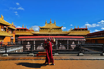
Kumbum Monastery
Kumbum Monastery was built in the year of 1379. It is one of the six most famed Ge-lug-pa lamaseries, is the birthplace of Master Tsongkhapa who founded the Ge-lug-pa Sect of Lamaism. The monastery houses many priceless art treasures, such as murals and Tangka paintings. It is also called Ta’er Monastery by the locals. Both Dalai Lamas and Panchen Lamas preached the word of Buddha at the monastery.
Menyuan Oilseed Rape Field
As the largest cultivated land of rape plants in the world, Menyuan Oilseed Rape Field covers an area of 333 square kilometers(129 sq.mi). It lies at the south of Qilian Mountain. The rape plant on the high plateau blooms in July. The best time to visit Menyuan Oilseed Rape Field is in mid-July.
How to Get to Qinghai
Xining Caojiapu International Airport is located 30 kilometers(18.6 miles) to the south of downtown Xining. It takes about half an hours to get to city proper from the airport by car. Currently, the airport operates flights to 46 domestic cities, such as Chengdu, Lhasa, Beijing, Shanghai, Guangzhou and Wuhan.
Tourists can also travel to Xining by bullet train from Xi’an or Lanzhou.
Climate
The climate in Qinghai is similar to that of Tibet. It has a cool summer and a harsh winter due to the high altitude. On the high plateau, the sun radiation is terribly strong and harmful, but the air is too thin to block off or retain heat. It leads to the temperature extremes which occur respectfully in the daytime and the nighttime during twenty-four hours. The sun’s ultraviolet rays are responsible for both tanning and burning. Please pack the suncream, sunglasses and sunhats for your tour in Qinghai.
How to Avoid Altitude Sickness
The average altitude of Tibet is over 4,000 meters(13,123 feet) above sea level. Some of the tourists will suffer from the Acute Mountain Sickness(AMS). Tips for you to prevent the AMS include keeping hydrated, avoiding a cold, acclimatizing to altitude gradually, avoiding rapid ascent, restraining from smoking and drinking alcohol.
Author: Tina Luo
Update: